Aware of the high off-road quotient of today’s ride, we ordered an 8 a.m. breakfast. It was just as well as Jan found it especially difficult to get going today. I was also aware that we might have to take food with us. Although various websites informed us that there was a thriving Mountain Bike Hire and licensed cafe at Ae, the village after which the forest was named, I also knew that there was no backup plan should that oasis prove to be deserted. A couple of days ago I had phoned the Glentrool visitors’ centre and was assured that there would be an adequate lunch for us on our arrival, and so there was. I tried phoning the Ae cafe several times but no-one answered. I feared the worst: that it was no longer serving. On the strength of that fear, we went into Thornhlill and stocked up on pro-thingstoeat. I bought some fruit cake slices and custard creams in the Co-op, some jelly babies in the Spar shop and a couple of steak pies and doughnuts at the baker’s.
Rather later than I intended, we set off. Leaving the village involved a climb, gentle initially but steeper later. We still haven’t encountered a chevron on this trip, but this morning must have been a close-run thing. There were plenty of occasions when we walked and Jan needed a rest, and the first 4 miles took us over an hour. Some of the roads in the area did not show up on the Garmin, although present on the OS map, including that down which a farmer on quadracycle and his two dogs drove a flock of 50 or so sheep and lambs. We also went under a railway bridge which, minutes earlier, had had a train cross it. There clearly had been a station there at one time, but now the nearest was Sanquhar, about 20 miles away.
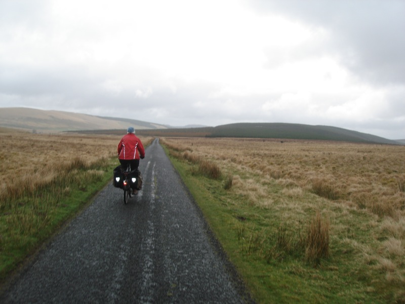
Once we were 1000 or so feet up, the next 8 miles were almost all downhill and our speed picked up. There was very little traffic on the road but whenever a car or cattle truck did turn up, we just stopped and let them past. There was rain in the air and, although the weather was mild, the landscape loses so much of its appeal under cloud cover.
Just before we arrived in Ae I stopped to take a photograph of a small cottage which boasted an enormous collection of motor bikes all around it. There were dozens of them. They looked fairly clean for the most part and many of them bore current tax discs, but there seemed to be nowhere to hide 70 or 80 superannuated hell’s angels. Neither had we seen any motorcyclists on the road. It was most bizarre.
Soon after 1 pm we arrived in the village and found the totally deserted cafe which had clearly carried out no business for quite some months and also proved the veracity of the answer to Radio 4’s oft-repeated rhetorical question:
“Ye’ll have had yer tea?”
“Ae.”
I congratulated myself on my foresight as I tucked into my excellent steak pie and doughnut. There was a family of mountain cyclists who had been trundling around bits of the forest and we had a conversation about closed cafes. Then, with some 12 miles of off-road track of unknown quality to traverse, we set off.
I’d done a fair bit of research into this bit of the ride. Googlemaps was sufficiently aware of the road that Bikehike would happily send a route along it. Furthermore, it was easy to pick out from aerial photographs as it snaked its way through dozens of square miles of conifer forest. The critical question was “Was it rideable?” and there was only one way to find out. However, I was encouraged by the following website:
http://www.dumgal.gov.uk/annanchamps/index.aspx?articleid=9728
Quote
Cycling around Dumfries
Locharbriggs and Heathhall
Local Cycle Route 10 runs from Dumfries Rail Station north on to Edinburgh Road out to Locharbriggs and Heathhall. For a great leisurely cycle ride in the countryside, follow Route 10 further north out to Ae Forest and Moffat.
We were further encouraged by a large blue Sustrans-style sign that told us that Moffat was 16 miles away along local cycle route number 10. Initially the surface was OK and we rode, but the signs advised us to leave my planned route and to follow a different track. Again, not a problem. The forest was a labyrinth of tracks like this and one would be very much like another.
We started to climb steeply and of course that meant getting off and pushing. Once again, I had no objection to this. I knew that we would be climbing to well over 1000′. Every so often the gradient lessened and we could ride, but progress, even by our standards, was slow. I had warned our landlady for the night that we might be late arriving, so she wouldn’t be sending out search parties unnecessarily.
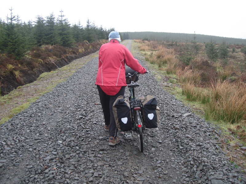
The worst bit, and I’d defy anyone to ride on this surface, was where the Forestry Commission had “repaired” the road by covering it in lumps of rock roughly the size of a cricket ball, but mostly cubic. On occasions more frequent than I care to recall we pushed our bikes up a steep ascent only to find that where the slope became rideable once again, some cretin had dumped tons of rubble all over it. Jan is not the most confident cyclist and is particularly unnerved when suddenly her back wheel leaps sideways on account of dreadful road surface. Neither is she given to displays of histrionics but at one point she screamed out of sheer frustration before giving me a vigorous hug just to tell me that she knew it wasn’t my fault. To describe this as “a great leisurely ride in the countryside” was about as far from the truth as it’s possible to be. Firstly, it was far from leisurely, and a Hard Slog would be a more appropriate description; secondly, much of the time we weren’t riding; and thirdly, when one’s view from the road is occupied entirely by unceasing millions of pretty much identical sitka spruce, it’s about as great as riding through a massive industrial complex.
Eventually two things improved: we reached about 1230′ above sea level, which meant that there would be a lot more downhill than up; and the unrideable “repairs” had stopped so we made much better progress. The first four miles of forest road had taken us over 2 hours to complete whereas the next 8 took us about the same amount of time so it was approaching 6 p.m. by the time we emerged onto a metalled, but very pot-holed road which led down the hill to the motorway junction and, beyond it, to Moffat. This was achieved without incident and we arrived at the B & B around 6.30, showered and went out to choose from several very promising looking pubs. The first we tried had no ale, just keg rubbish, so we tried another, The Star. This did a very good pint of a local brew named Criffel and a very succulent, and excellent value, sirloin steak. We also learned that it has earned a mention in the Guinness Book of Records on account of its dimensions: 20′ wide and 162′ long.